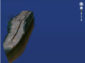
Now you can use Google Earth to explore the Titanic 3D model from the comfort of your home.
After the Titanic superliner (other word for ship) collided with an iceberg, it sank in the North Atlantic Ocean. Years later the story has inspired books and movies (3D movies) and is memorialized in museums and monuments.
The ship went down in 1912 — almost 100 years ago.
Google now believes this ill-fated ship deserves your attention, so they have partnered with National Geographic and a couple of Research institutes including NOAA to help you tour the Titanic shipwreck using the free Google Earth tool.
3D Titanic Model on Google Maps and Earth:
To view the 3D model, you need to download this KMZ file. This file can be opened in Google Earth.
After you have launched Google Earth, on the left panel you will notice a drop-down menu, click on Model (screenshot) and Google Earth will zoom into the location of Titanic.